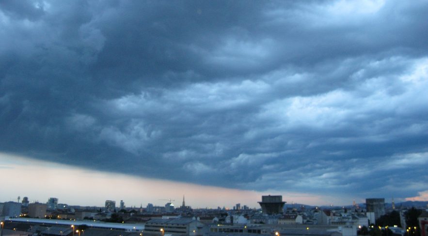
The number of major floodings in Europe is markedly increasing in the recent years. Each time, there is a broad discussion about natural causes, the influence of human factors like infrastructure and river regulation as well as attribution of climate change. One thing is clear: Humankind is changing the landscape for centuries, the number of people occupying former flooding areas is constantly increasing. Irrespective of the degree of flooding, more people will be affected from flooding in general at some time. It’s not possible to take out humans from the equation like anthropogenic warming deniers do it regularly. There is also a natural variance of flooding events with recurring major disasters in the past, sometimes prompting to make modifications for river regulation. Apart from the situation on the ground, it is impossible to deny the increasing amounts of rain with rising intensity where climate changes steps in.
I decided to write this analysis in English as I’d like to cover quite some meteorological aspects of this event, where I need a lot of scientific terms. Moreover I want to make this analysis available for foreign readers, too.
Update, 08.11.24
The latest analysis is from ESSL:
Tomas Pucik: Meteorological analysis of extreme flash flood situation in the Valencia region (05.11.24)
Alois Holzer: Historical deadly flash floods in Spain (31.10.24)
Very similar conclusions. Interesting note: The moist boundary layer prevented the generation of strong cold pools and outflow boundary which new cell initation elsewhere. Another conducive factor for persistent backbuilding storms.
Who is to blame for Valencia flooding deaths? A weather warning expert on how the disaster unfolded (Euro News, 07.11.24)
„“Just providing numbers of rainfall totals (e.g. 400mm in 12 hours) without describing relevant impacts and possible measures to protect life and property is of little use unless one has some background in meteorology.”
Lars Lowinski, chartered meteorologist
Same problem in Lower Austria with the devastating flood in Mid September 2024.
Flooding history of Valencia
Valencia is situated at the coastal line of the Balearic Sea, with surrounding mountains farther inland, the Sistema Iberico in the northwest up to 1500m amsl and the Meseta Central up to 700m amsl. Rio Túria is the result of its headstreams Guadalaviar (Sierra de Albarracin) and Rio Alfambra (Sierra de la Moratilla), passing Valencia after 280km.
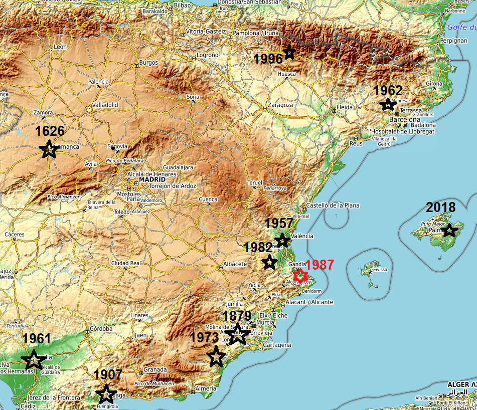
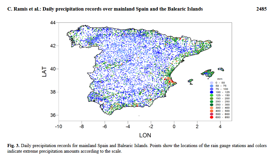
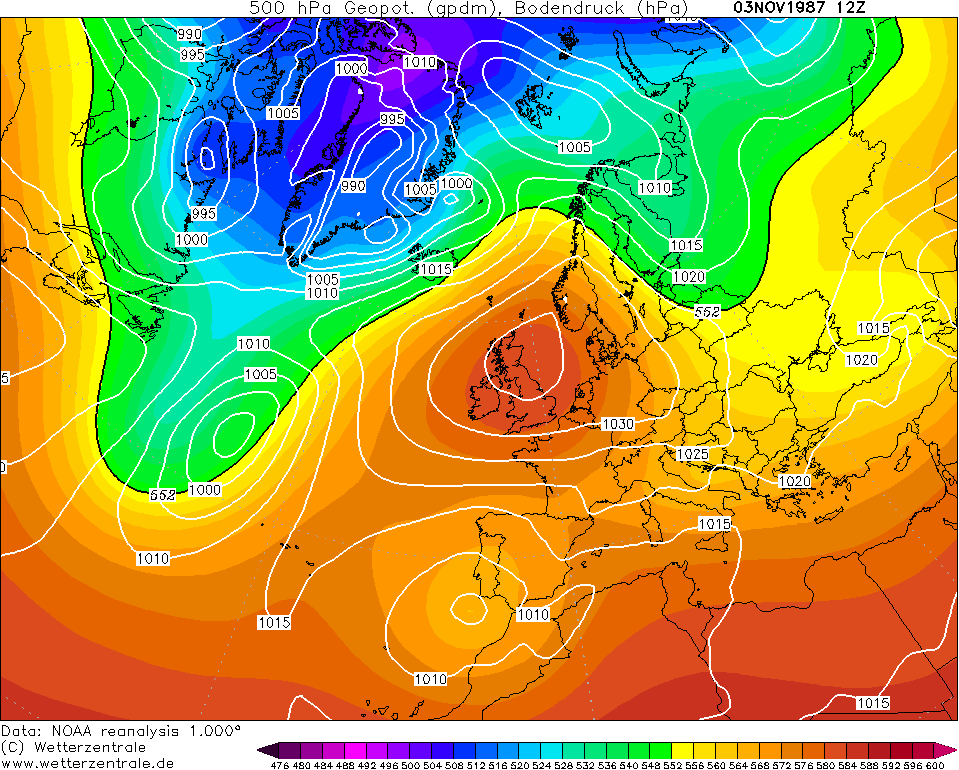
The Mediterranean region has always been in the focus of severe rain events in autumn when the first spell of cold upper-level air extends over the still heated sea, causing large instability and severe thunderstorms. It’s called dana in Spain, for depresión aislada en niveles altos (very detailed description here). Given a favourable easterly flow, the combination of strong deep moist convection and upstream flow alongside the coastal mountain range is able to raise the river levels in a short time. Current all-time record for 24 hr precipitation is 817mm in Oliva, Valencia on 3th November 1987.
The last comparable flood in Valencia took place on 14th October 1957, causing at least 81 deaths and enormous material damage. The first wave struck during the night 13/14th October, with heavy rain upstream of Valencia (200-235mm in 12 hrs). In the afternoon a second wave also struck Valencia, with 90mm within 40min (total amounts 125mm). The runoff increased from 165m³/s to 2700 m³/s during the first wave up to 3700 m³/s at the peak of the second wave, reaching up to 5 metres height in the lower parts of the cities.
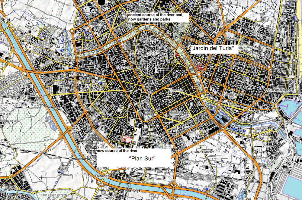
As a consequence, the river has been regulated and deviated from its original course through an artificial river bed, starting in 1958 and being finished in 1973. Planners thought the city would grow north and west the after rerouting but most new city parts developed south of the new Turia course. The river channeling also enhanced the risk of a faster flow and higher water levels downstream, with greater risk of flooding.
Slightly different situation with the blocking high over UK but very moist and unstable air mass advection ahead of the upper-level low and surface depression.
Comparison of 1957 and 2024
While large-scale synoptics appear to be quite similar at the peak time of the event, the developing upper and low-level systems display some differences which is reflected in the large differences of the rain amounts too.
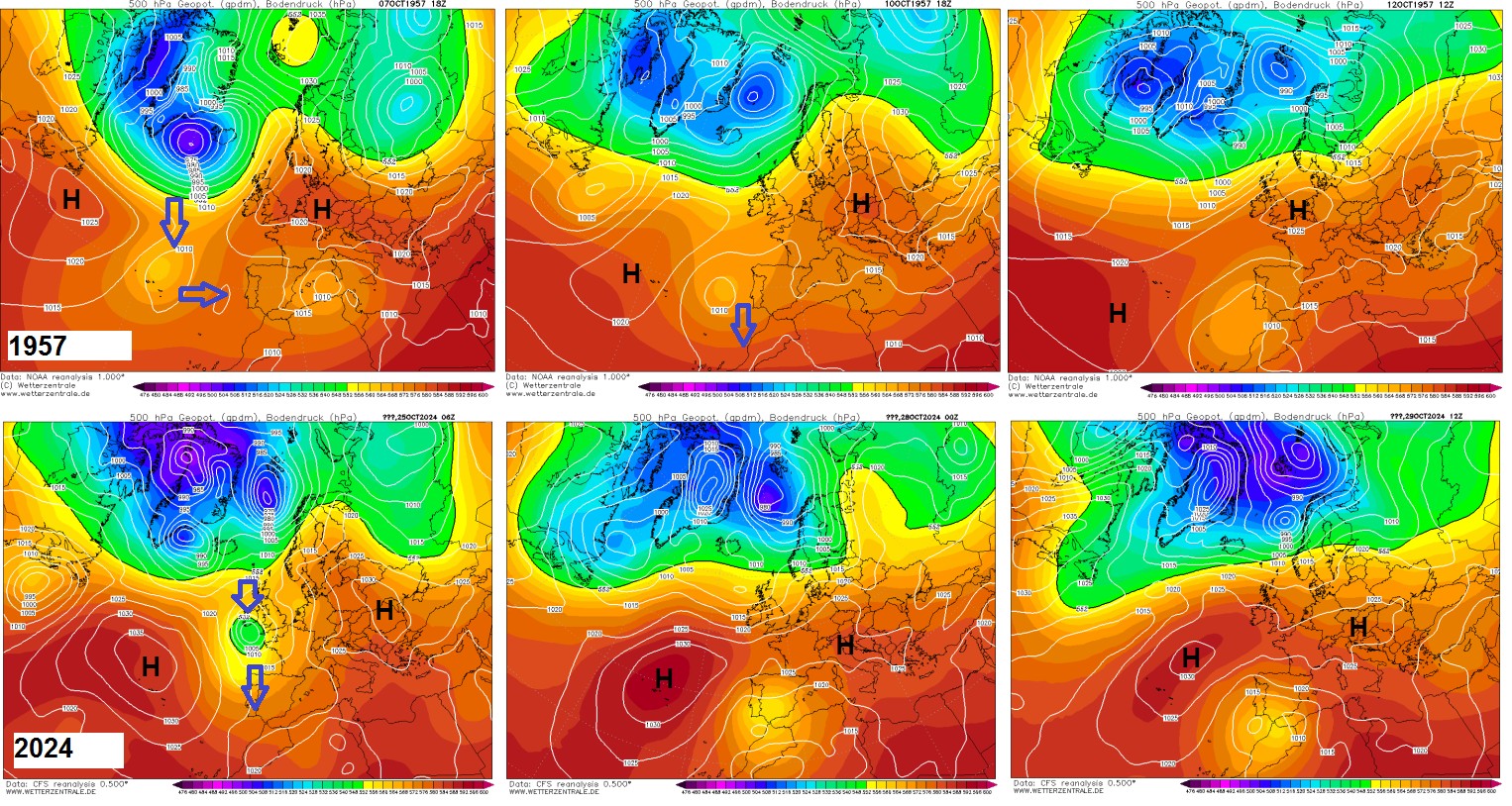
In 1957 the cut-off process started far west near the Azores islands, then slowly drifting eastward, with a surface low (no classic cold air drop). The broad upper-level low then moved southward. At the peak of the event, a significant easterly flow was present but rather weak upper-level flow which could explain the comparatively low rain amounts (no sustained deep-moist convection). However, a strong surface low has been present a fews days before in the area, and the foregoing precipitation event may have strengthened the degree of flooding.
In 2024, the cut-off process took place further east over UK, then moving southward towards the Iberian Peninsula. In general, the upper-level ridges were more pronounced with higher geopotential heights than in 1957. They also lied above the 850mb mean temperature (1991-2020), i.e., well above the 1961-1990 mean. The upper-level-low has been much deeper than in 1957 and the upper-level flow on the front side has also been much stronger. At the peak of the event, a small-scale surface low developed south of Valencia, enhancing low-level flow and convergence as well as orographic precipitation in the area of interest.
So at the first glance, upper and low-level system have been much more distinct in the case of the 2024 event: stronger jetstream, stronger low-level flow, more pronounced warm air advection. Unseasonably strong 500mb geopotential heights north of the area may also play an important role here, by increasing the gradients.
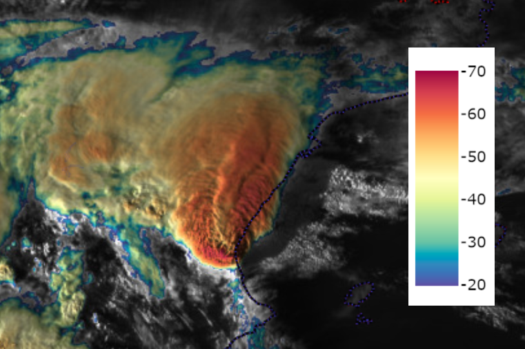
Case study of 29th October 2024
Like in 1957, the flashflood event came in two waves. The first wave struck the area in the morning of 29th October between 04 and 08.30 UTC, with a nearly stationary multicell cluster. The second wave started around 12.30 UTC, initally affecting the drainage area west and southwest of Valencia. The peak convergence occurred between 13.45 and 18.45 UTC with main cloud tops well below -60°C, locally up to -70°C. Several and strong tornadoes happened at the same time south of Valencia, indicating the strength of the low-level convergence there.
Ingredients-based Forcing
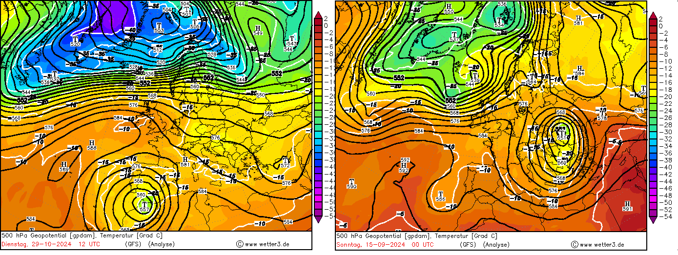
In both historic flood events, the upper-level low has been exceptionally large and strong, indicating maximized warm air advection and dynamic forcing (pva maxima). The event in September affecting Eastern Austria, Czechia and Poland drew very moist and unstable air masses from the Black Sea while the Spain event had warm and quite unstable air mass with origin from North Africa.
The upper-level low became so deep because of downstream development with the following strong Azores high. The low then became trapped within both ridges over the Azores and Ctrl Mediterranean. For some time on Monday, 28th October, the center of the upper-level low lied between Morocco and Portugal over the open sea, with about -22°C in 500mb and +21°C SST (03th November 2024), quite a strong lapse rate which could have helped sustaining the geopotential minimum of the low.
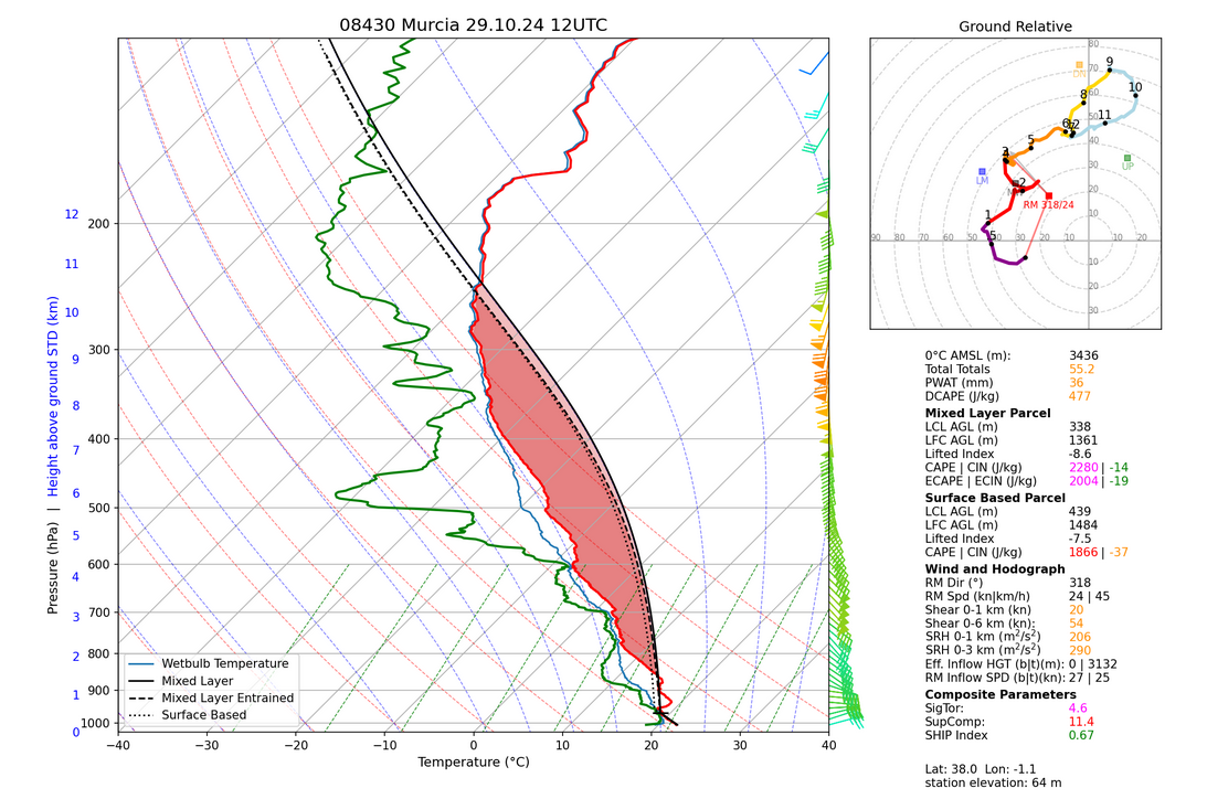
The Murcia sounding reveals big CAPE and very low LCLs, strong low-level and deep-layer shear with significant index values for significant tornadoes and supercell storms. Moreover, strong low-level easterlies enhancing orographic precipitation.
In general, the strong upper-level flow has been conducive for multicell storms, i.e. large areas were affected by heavy precipitation. Backbuilding storms are favoured by stationary low-level convergence lines.
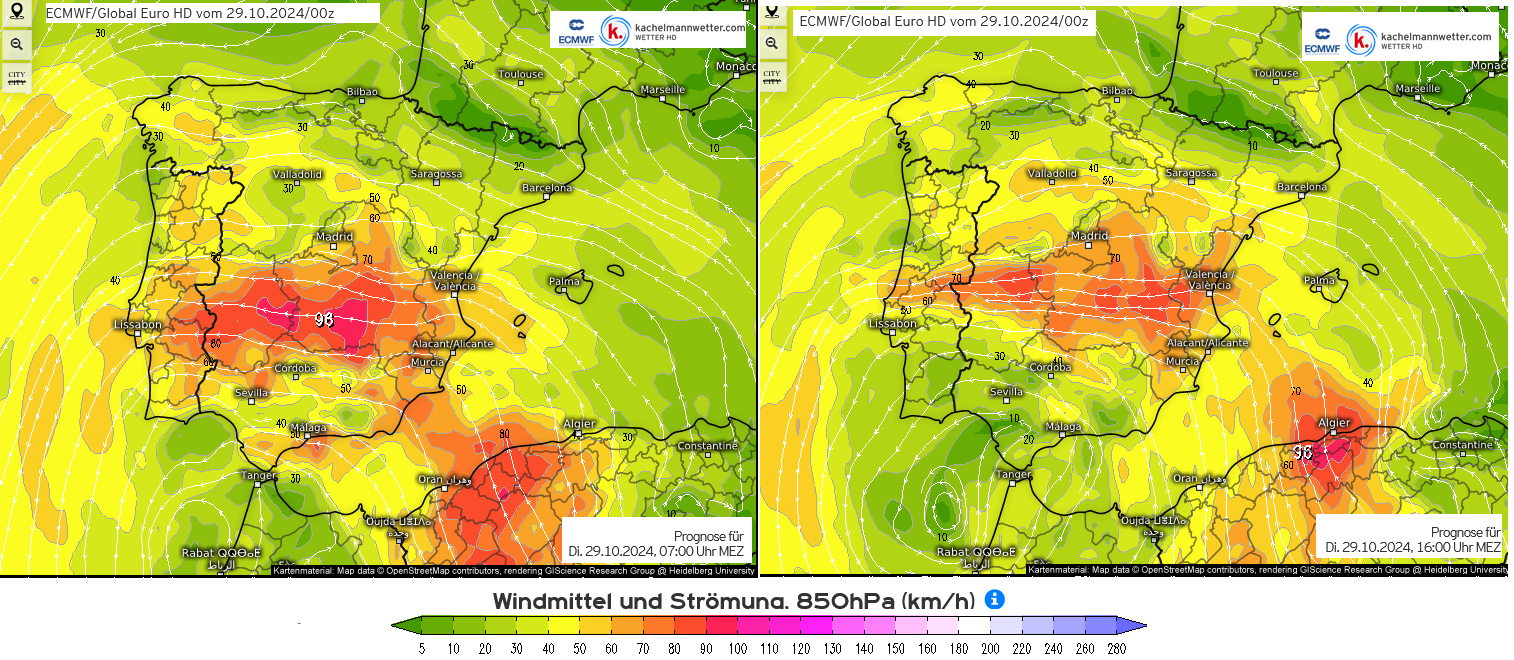
Unfortunately I couldn’t find respective scatterometer data oversea from that time but ECMWF 00z run shows a vigorous low-level easterly flow over and west of Valencia, and a LL convergence is very likely given the southeasterly winds in the range of the low and the more easterly winds due to the proximity of the high pressure area.
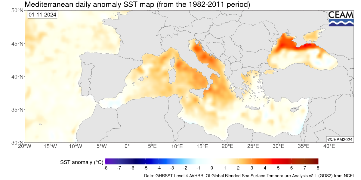
SST have only been slightly above normal, probably in the order of 1-2K.
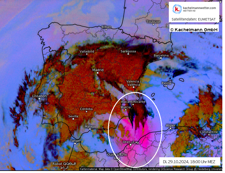
Enormous Sahara dust transport south of Valencia in the evening of Tuesday.
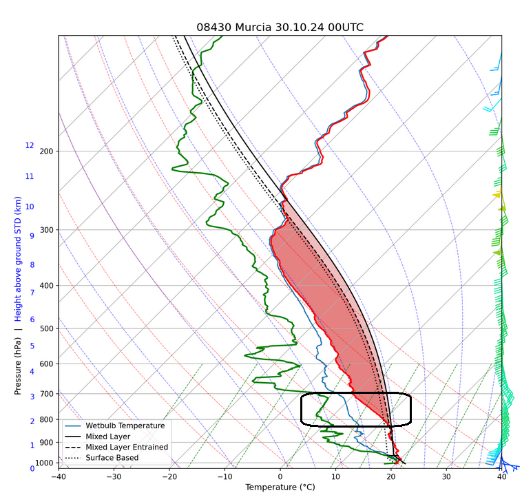
Steamy boundary layer air mass and very dry air above, with a textbook elevated mixed layer revealing the advection of Sahara dust in mid-levels. In comparison with Muria 12z, the elevated mixed layer has rosen from 900/800mb to 800/700mb.
Summary:
All ingredients for severe deep moist convection, strong tornadoes and orographically enhanced precipitation have been present for hours. In terms of climate change attribution, slightly too warm SST over the Mediterranean Sea could have contributed to the intense rain rates. However, no extreme PWAT values have been observed (mostly 30-40mm).
Main reason for the strong convection is the depth of the upper-level low, with probably below-average 500mb core temperatures and the strong upper-level gradient with above-normal 500mb ridge heights, later reflected by record-high zero line in the alpine region (well above 3500m) and above-average 850mb temperature anomaly.
Model performance:
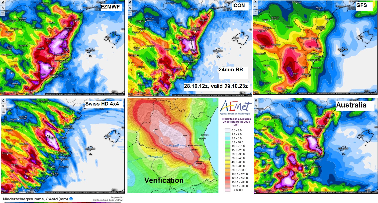
About 12 hours before the event, Swiss HD (Cosmo?) had the best performance with location and degree of precipitation (locally up to 200mm). ECMWF wasn’t bad either and even the australian model showed the peaking amounts at the right place. ICON had it too close to the coastal area and GFS was a nothingburger.
However, all models failed to simulate high-end observed precipitation with 400mm and higher.
Impact of the flash flood event in the area:
Large parts of the coastal area were flooded:
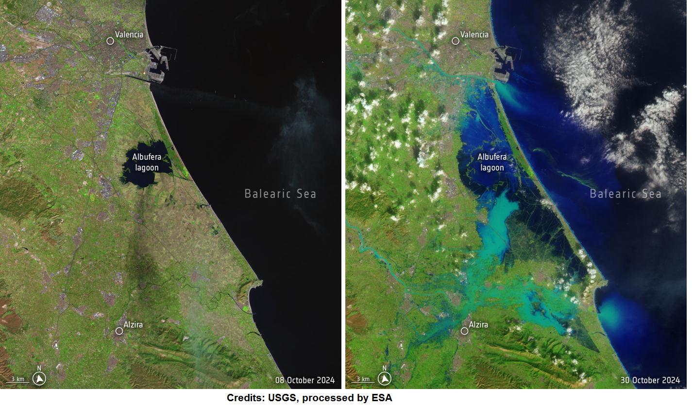
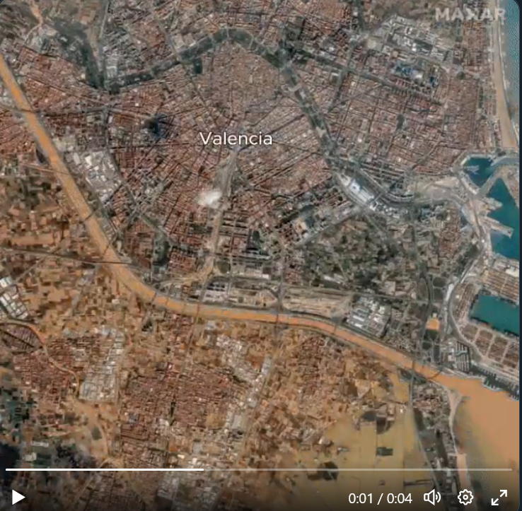
In Valencia, most of the damage occurred alongside and south of the rerouted river bed.
- Chiva, W of Valencia: 491,2mm in 24 hrs, 343mm in 4 hrs (16.30-20.30), 160mm in 1 hr.
- Réseau Toris, Canyapar, La Ribera Alta, S of Chiva: 630,6mm in 24 hrs (private Davis)
- Utiel, situated far W of Chiva, Meseta Central: widespread 300mm in 24 hrs
- Mojonera, between Godelleta – Turis – Calicanto, SE of Chiva: 784,4mm in 24 hrs
The annual precipitation in the region of Valencia is in the order of 400-800mm.
At the time of publishing this article, 211 people already died and about 1900 are still missing. 77 000 buildings were affected by the flood in and near Valencia.
Update, 09.11.24 – official data (AEMET):
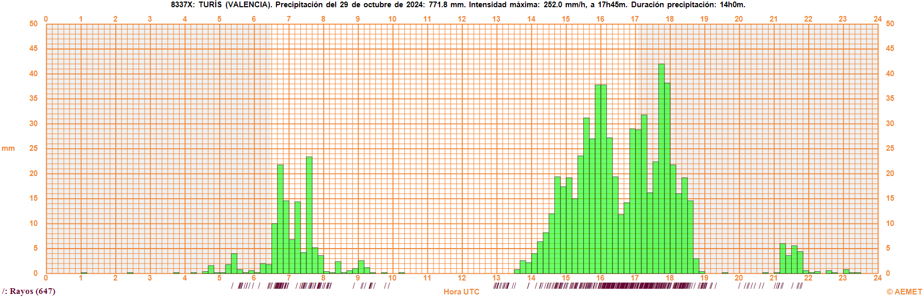
Turís (Mas de Calabarra), SW of Valencia: 771,8mm in 24 hrs.
- 10min: 42mm
- 30min: 102,8mm
- 60min: 184,6mm
- 2 hrs: 319,6mm
- 3 hrs: 476,2mm
- 4 hrs: 581,0mm
- 5 hrs: 616,8mm
- 6 hrs: 620,6mm
Final statement:
Countless flooding events this year in Europe are the result of above-normal SST of the surrounding seawater, starting with SW Germany in May, the S Germany flooding end of May/Begin of June and a single record rain event in Vienna in August. We saw severe flooding in mid September in Slovenia, Austria, Poland and Czech Republic. There was flooding in S France later on as well as in England at the beginning of 2024. Last year, S Austria was heavily affected by a rain event. Greece and Libya have been struck by storm DANIEL – with about 24 000 people dying after a dam collapse in Derna and widespread agriculture damage in in the Thessalian plain (He et al. 2023 preprint).
In the context of these recurring flood events, oftentimes caused by SST anomalies and well-defined convective storms, the Valencia flood fits into the observed pattern of extreme rain events due to climate warming, with long-during dry periods in between. However, regular floods happened at the eastern coastal line of Spain (Levante) in the past. And of course, population density is much higher today than a hundred years ago or centuries before – so even if the intensity of the event wouldn’t change, then impact will be much higher. This year’s event has been outstanding in terms of rain rates within a short time, probably overturning the 1987 event. Even if taking the rerouting of rivers into account, the observed rain amounts were significant, also affecting smaller towns further upstream.
From a climatological perspective nothing surprising happened: We expected to see this blocking situations unfolding, as well as above-normal SST in the Mediterranean Sea. Dynamics played a major role here where a above-normal strong ridge kicked in, by strengthening the upper-level low downstream. One could argue that even in the absence of extraordinary SST, strong dynamic forcing would have caused such intense storms. So there is a global warming contribution to this event but maybe smaller than with earlier events this and in recent years.
Irrespective of the exact share of global warming here, authorities failed to warn the people appropriately. Many people died in their cars during rush hour in the narrow streets where they couldn’t escape the tsunami-like floods anymore. It will be difficult to adapt infrastructure to high-end intensity rain rates in the short term, so there must be at least warnings in time to save lives. It will be necessary to issue information and first action plans several days in advance, if possible. Evacuation plans are also necessary
Epilogue: New flood warnings today with total rain amounts up to 200mm until midnight for the region south of Valencia (according to AROME), heavy flooding reported in Puerto de Mazarrón, Murcia.
